99 Future Lane
Rawdon Ward, Stirling-Rawdon, K0K 2M0
$129,900
- 0 bedrooms
- 0 bathrooms
Listed 17 days ago · MLS® X13858268
About this home
Here's your chance to own just over 5 and a half acres of pristine untouched wilderness on the Moira River. Accessible off a private road (Future Lane) north of Stirling and east of Marmora, this property could be a place for you to get away from the hustle and bustle of civilization. Live off grid if that appeals to you or bring in electricity from just up the lane. In consultation with Quinte Conservation and the town of Stirling you might be able to make this your own dream cottage destination!
Details
- Type
- Vacant Land
- Lot
- 207 × 1006 ft
- Kitchens
- 0
- Property tax
- $1,044 (2026)
- Neighbourhood
- Rawdon Ward
- Municipality
- Stirling-Rawdon
Building and exterior
- Faces
- East
- Waterfront
- Direct
Lot
- Size
- 207 × 1006 ft (irregular)
- Acreage
- 5-9.99
More
- Possession
- Immediate
- Cross street
- Stirling-Marmora Rd and Spry Rd at Bonarlaw
History of this address
1 earlier listing at this address, with sold and leased prices. Create a free account or sign in to see them.
Location
Location is approximate. See nearby homes on the map
Recent sales nearby
See what similar homes within 1 km sold for in the last year. Create a free account or sign in to see them.
The neighbourhood
Getting around Car-dependent
No subway, LRT or GO station within a short trip.
Within a 10-minute walk: no grocery stores, 0 cafés and restaurants, 0 parks.
Who lives here postal area K0K
- Owners / renters
- 86% / 14%
- Median household income
- $83,000
- Average age
- 47
- Children under 15
- 14%
- Homes
- 90% detached, 0% high-rise
- Commute by transit
- 0%
- Population
- 115,850
Languages spoken most at home besides English: German 0.2%, Spanish 0.1%, Mandarin 0.1%, Korean 0.1%.
Safety
Crime Severity Index for Central Hastings (Stirling-Rawdon) (OPP): 30 vs 57 for Ontario (2025).
Police-reported figures for the whole police service area, not this street. Rates use the area’s resident population.
Distances are approximate. Places © OpenStreetMap contributors. Neighbourhood figures: Statistics Canada, 2021 Census. Crime Severity Index: Statistics Canada.
Living here
Commute
Noise Nothing major nearby
No highway within 500 m, rail line within 300 m, or airport flight path nearby.
Distances from the map, not noise measurements. Visit at rush hour to judge for yourself.
Internet High-speed
50/10 Mbps or faster available here by cable, fibre or DSL (the federal high-speed target).
From the federal broadband map. Check exact speeds and providers for the address.
Roads, rail, airports and planned stations © OpenStreetMap contributors. Internet: Innovation, Science and Economic Development Canada, National Broadband Data.
Listed by Royal Heritage Realty Ltd..
Listing information provided by PropTx Innovations Inc. and TRREB; deemed reliable but not guaranteed accurate by PropTx.
Similar homes nearby
See more in Stirling-Rawdon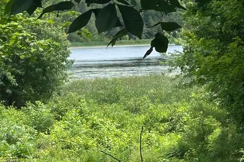
$129,900
0 bd0 ba4 pk
331 W Swinburne Lane E
Rawdon Ward, Stirling-Rawdon
Vacant Land · MLS® X13501058 · Homelife Superior Realty Inc.