660 Main Street
Woodstock - South, Woodstock, N4S 3N9
$299,000
Listed 21 days ago · MLS® X13837882
About this home
Approximately 1.25 acres Industrial land available for development to suit your specific industrial needs. The property is suitable for a wide range of Industrial applications, making it a versatile investment opportunity. M4 Zoning permits include Motor vehicle Dealership, service shop, parking, Public Garage, Bus storage facility, contractor's yard, fabricating Plant, machine shop, distribution, warehousing, manufacturing plant and much more. The property is making it an excellent opportunity for investors or business owners looking to expand. Services at property line. The seller is highly motivated to sell both 650 Main Street and 660 Main Street. Both properties can be purchased together as a package, providing an excellent opportunity for a buyer looking to acquire both lots. Buyer or Buyer's agent to verify all information. Please note that the shaded areas and the dividing line between the two lots shown in the listing photos are AI-generated for illustrative purposes only. The actual lot dimensions and boundaries are shown on the surveys attached to the listing. Please refer to the attached surveys for accurate measurements and property boundaries. Seller is RREA .Please note: Price is firm. No lowball offers, please.
Details
- Type
- Land
- Lot
- 184.48 × 303.84 ft
- Property tax
- $1,974 (2026)
- Neighbourhood
- Woodstock - South
- Municipality
- Woodstock
Heating, cooling and services
- Water and sewer
- Sanitary+Storm
- Utilities
- Available
Building and exterior
- Building area
- 1 Acres
More
- Possession
- Immidiate
- Cross street
- Main/Wilson
- Business type
- Industrial
Location
Location is approximate. See nearby homes on the map
Recent sales nearby
See what similar homes within 1 km sold for in the last year. Create a free account or sign in to see them.
The neighbourhood
Getting around Walkable
No subway, LRT or GO station within a short trip.
Within a 10-minute walk: 2 grocery stores, 14 cafés and restaurants, 1 park, 1 pharmacy. Nearest grocery: Foodland (500 m). Nearest park: South Side Park (850 m).
Schools nearby
Elementary
- Oliver Stephens Public School
EQAO: Gr 6 reading 93%, math 57%13 min walk - Central Public School
EQAO: Gr 6 reading 69%, math 25%16 min walk - Winchester Street Public School
EQAO: Gr 6 reading 71%, math 33%18 min walk - Eastdale Public School
EQAO: Gr 6 reading 87%, math 33%18 min walk
Secondary
- College Avenue Secondary School
EQAO: Gr 9 math 28%, literacy test 66%10 min walk - Woodstock Collegiate Institute
EQAO: Gr 9 math 54%, literacy test 88%14 min walk - Huron Park Secondary School
EQAO: Gr 9 math 52%, literacy test 76%1.4 km
EQAO: share of students meeting the provincial standard (2024–25). Ontario average: Gr 6 reading 86%, math 51%; Gr 9 math 55%; literacy test 83%.
Closest schools, not school zones. Check which school serves this address with the school board before relying on it.
Who lives here postal area N4S
- Owners / renters
- 66% / 34%
- Median household income
- $78,000
- Average age
- 43
- Children under 15
- 16%
- Homes
- 63% detached, 5% high-rise
- Commute by transit
- 1%
- Population
- 33,055
Languages spoken most at home besides English: Punjabi (Panjabi) 0.5%, Polish 0.3%, Spanish 0.3%, Portuguese 0.2%.
Safety
Crime Severity Index for Woodstock police: 62 vs 57 for Ontario (2025).
Police-reported figures for the whole police service area, not this street. Rates use the area’s resident population.
Distances are approximate. Places © OpenStreetMap contributors. Neighbourhood figures: Statistics Canada, 2021 Census. School results: EQAO via Ontario Data Catalogue (Open Government Licence – Ontario). Crime Severity Index: Statistics Canada.
Living here
Commute
Noise 1 source nearby
- 🚆 Rail line (Dundas Subdivision)150 m
Distances from the map, not noise measurements. Visit at rush hour to judge for yourself.
Internet High-speed
50/10 Mbps or faster available here by cable, fibre or DSL (the federal high-speed target).
From the federal broadband map. Check exact speeds and providers for the address.
Roads, rail, airports and planned stations © OpenStreetMap contributors. Internet: Innovation, Science and Economic Development Canada, National Broadband Data.
Listed by COLDWELL BANKER SUN REALTY.
Listing information provided by PropTx Innovations Inc. and TRREB; deemed reliable but not guaranteed accurate by PropTx.
Similar homes nearby
See more in Woodstock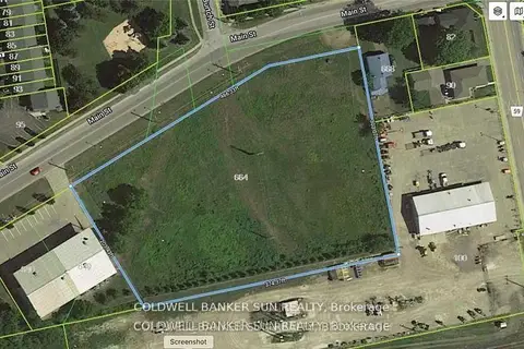
$299,000
650 Main Street
Woodstock - South, Woodstock
Land · MLS® X13837880 · COLDWELL BANKER SUN REALTY