649 Taunton Road W
Northwest Ajax, Ajax, L1T 4R6
$8,500,000
Listed 129 days ago · MLS® E13441802
About this home
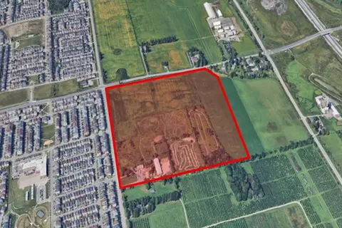
Rare chance to acquire two contiguous parcels comprising approximately 4.01 acres (174,655 SF) of development land with a combined 478 feet of prime frontage on Taunton Road West, one of Ajax's key east-west arterial corridors, located in the rapidly growing Northwest Ajax area. VENDOR FINANCING OR JV OPPORTUNITIES AVAILABLE The properties are currently zoned CR (Commercial Residential) under the Town of Ajax Zoning By-law, permitting a range of residential and commercial uses, subject to zoning regulations. and municipal approvals. The site offers strong long-term redevelopment and intensification potential within an established growth corridor. Strategically located minutes to Highways 401, 407, and 412, the site benefits from excellent regional connectivity and proximity to established residential neighbourhoods, retail amenities, schools, and transit. The parcels feature an irregular configuration, direct ingress/egress from Taunton Road West, and existing private septic servicing. Buyer to verify future servicing requirements. The lands are currently improved with two detached dwellings: however, the properties are being marketed and valued for land and redevelopment potential only. Opportunities of this scale, frontage, and location along Taunton Road West are increasingly limited. Ideal for developers, builders, and land investors seeking a sizeable assembly in Durham Region growth corridor. The offering consists of:649 Taunton Road West (Roll No. 180501001113305)669 Taunton Road West (Roll No. 180501001113310)Each property is legally separate with its own roll number; however, they are being marketed collectively as a single land assembly. Buyer to verify zoning, permitted uses, density, servicing, and development potential. Owner highly flexible with price and terms. Buyer to verify zoning, permitted uses, density, servicing, and development potential
Details
- Type
- Land
- Lot
- 213 × 410.85 ft
- Property tax
- $5,893 (2025)
- Neighbourhood
- Northwest Ajax
- Municipality
- Ajax
Heating, cooling and services
- Utilities
- Available
Building and exterior
- Building area
- 4 Acres
More
- Possession
- Flexible -Immed.
- Cross street
- Taunton Rd W & Church St N.
- Business type
- Residential
History of this address
1 earlier listing at this address, with sold and leased prices. Create a free account or sign in to see them.
Location
Location is approximate. See nearby homes on the map
Recent sales nearby
See what similar homes within 1 km sold for in the last year. Create a free account or sign in to see them.
The neighbourhood
Getting around Car-dependent
- 🚆 Ajax GO5.0 km
Within a 10-minute walk: no grocery stores, 0 cafés and restaurants, 0 parks.
Schools nearby
Elementary
- Rosemary Brown Public School
EQAO: Gr 6 reading 96%, math 48%1.8 km - Vimy Ridge Public School
EQAO: Gr 6 reading 91%, math 47%2.2 km - St. André Bessette Catholic School Catholic
EQAO: Gr 6 reading 86%, math 50%2.3 km - Alexander Graham Bell Public School
EQAO: Gr 6 reading 88%, math 60%2.4 km
EQAO: share of students meeting the provincial standard (2024–25). Ontario average: Gr 6 reading 86%, math 51%; Gr 9 math 55%; literacy test 83%.
Closest schools, not school zones. Check which school serves this address with the school board before relying on it.
Who lives here postal area L1T
- Owners / renters
- 88% / 12%
- Median household income
- $130,000
- Average age
- 38
- Children under 15
- 18%
- Homes
- 74% detached, 2% high-rise
- Commute by transit
- 8%
- Population
- 52,632
Languages spoken most at home besides English: Tamil 4%, Urdu 3.2%, Dari 1%, Punjabi (Panjabi) 1%.
Flood and conservation No mapped hazard
Not inside a mapped flood plain or regulated area.
Screening maps only. Ask the conservation authority for a property inquiry before relying on this.
Safety
Crime Severity Index for Durham Region (Oshawa/Whitby/Ajax) police: 43 vs 57 for Ontario (2025).
Police-reported figures for the whole police service area, not this street. Rates use the area’s resident population.
Distances are approximate. Places © OpenStreetMap contributors. Neighbourhood figures: Statistics Canada, 2021 Census. School results: EQAO via Ontario Data Catalogue (Open Government Licence – Ontario). Crime Severity Index: Statistics Canada.
Living here
Commute
To Union Station (downtown Toronto): 37 km. Transit times · Driving times
Noise 1 source nearby
- 🚆 Rail line (Belleville Subdivision)300 m
Distances from the map, not noise measurements. Visit at rush hour to judge for yourself.
Internet High-speed
50/10 Mbps or faster available here by cable, fibre or DSL (the federal high-speed target).
From the federal broadband map. Check exact speeds and providers for the address.
Roads, rail, airports and planned stations © OpenStreetMap contributors. Internet: Innovation, Science and Economic Development Canada, National Broadband Data.
Listed by ROYAL LEPAGE SIGNATURE REALTY.
Listing information provided by PropTx Innovations Inc. and TRREB; deemed reliable but not guaranteed accurate by PropTx.
Similar homes nearby
See more in Ajax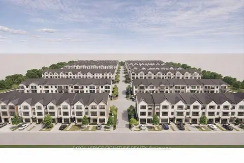
$8,500,000
669 Taunton Road W
Northwest Ajax, Ajax
Land · MLS® E13444832 · ROYAL LEPAGE SIGNATURE REALTY
 New
$7,999,999
777 Audley Road N
Central East, Ajax
Farm · MLS® E14094950 · REN/TEX REALTY INC.