5881 Thorold Stone Road
205 - Church's Lane, Niagara Falls, L2J 1A1
$3/mo
Listed 276 days ago · MLS® X12705012
About this home
Large-scale industrial leasing opportunity offering up to approximately 325,000 sq. ft. on an expansive 18-acre site, with the ability to accommodate users requiring less space through flexible demising options. The facility provides a range of clear heights from roughly 14.7 ft. to 31 ft., supporting a wide variety of industrial, warehouse, and distribution operations. Shipping infrastructure includes existing drive-in access, recessed loading areas, and multiple locations suitable for additional dock or grade-level doors. The building is constructed with heavy-duty concrete flooring and is supported by a substantial outdoor yard with gravel surfacing, ideal for equipment storage, fleet parking, and efficient truck circulation with ample turning radius. A crane bay area is present within the building, subject to servicing of the crane rail. Office space can be incorporated as required. The property benefits from natural light, gas servicing throughout, basic electrical lighting in select areas, and on-site washroom facilities, with the sprinkler system currently undergoing upgrades. A separate standalone shop of approximately 5,544 sq. ft. is also available, featuring a 13-ft. clear height, oversized drive-in door, gas heating, washroom, and its own yard and parking area. General Industrial zoning allows for a broad range of permitted uses, and a former rail spur remains on the property.
Details
- Type
- Industrial
- Garage
- Other
- Property tax
- $2 (2025)
- Neighbourhood
- 205 - Church's Lane
- Municipality
- Niagara Falls
Heating, cooling and services
- Utilities
- Available
Building and exterior
- Building area
- 325,000 Square Feet
Rental terms
- Minimum term
- 36 months
More
- Possession
- TBD
- Cross street
- Thorold Stone Rd & Queen Elizabeth Wy
History of this address
1 earlier listing at this address, with sold and leased prices. Create a free account or sign in to see them.
Location
Location is approximate. See nearby homes on the map
The neighbourhood
Getting around Walkable
No subway, LRT or GO station within a short trip.
Within a 10-minute walk: 3 grocery stores, 7 cafés and restaurants, 4 parks, 2 pharmacies. Nearest grocery: Commisso's Fresh Foods (450 m). Nearest park: Stamford Lion’s Park (400 m).
Schools nearby
Elementary
- St. Gabriel Lalemant Catholic Elementary School Catholic
EQAO: Gr 6 reading 100%, math 27%9 min walk - John Marshall Public School
EQAO: Gr 6 reading 100%, math 75%12 min walk - École élémentaire catholique Saint-Antoine Catholic · French
EQAO: Gr 6 reading 79%, math 29%17 min walk - Notre Dame Catholic Elementary School Catholic
EQAO: Gr 6 reading 96%, math 75%18 min walk
Secondary
- A. N. Myer Secondary School
EQAO: Gr 9 math 74%, literacy test 89%15 min walk - Saint Paul Catholic High School Catholic
EQAO: Gr 9 math 81%, literacy test 84%1.4 km
EQAO: share of students meeting the provincial standard (2024–25). Ontario average: Gr 6 reading 86%, math 51%; Gr 9 math 55%; literacy test 83%.
Closest schools, not school zones. Check which school serves this address with the school board before relying on it.
Who lives here postal area L2J
- Owners / renters
- 81% / 19%
- Median household income
- $81,000
- Average age
- 47
- Children under 15
- 13%
- Homes
- 71% detached, 7% high-rise
- Commute by transit
- 1%
- Population
- 14,908
Languages spoken most at home besides English: Italian 1.1%, Spanish 0.8%, Serbian 0.4%, Korean 0.4%.
Flood and conservation No mapped hazard
Not inside a mapped flood plain or regulated area in Niagara Peninsula Conservation’s mapping.
Screening maps only. Ask the conservation authority for a property inquiry before relying on this.
Safety
Crime Severity Index for Niagara Region (St. Catharines) police: 54 vs 57 for Ontario (2025).
Police-reported figures for the whole police service area, not this street. Rates use the area’s resident population.
Distances are approximate. Places © OpenStreetMap contributors. Neighbourhood figures: Statistics Canada, 2021 Census. School results: EQAO via Ontario Data Catalogue (Open Government Licence – Ontario). Flood and regulation mapping: Niagara Peninsula Conservation open data. Crime Severity Index: Statistics Canada.
Living here
Commute
To Union Station (downtown Toronto): 63 km. Transit times · Driving times
Noise 1 source nearby
- 🚆 Rail line (Stamford Subdivision)100 m
Distances from the map, not noise measurements. Visit at rush hour to judge for yourself.
Internet High-speed
50/10 Mbps or faster available here by cable, fibre or DSL (the federal high-speed target).
From the federal broadband map. Check exact speeds and providers for the address.
Roads, rail, airports and planned stations © OpenStreetMap contributors. Internet: Innovation, Science and Economic Development Canada, National Broadband Data.
Listed by RE/MAX METROPOLIS REALTY.
Listing information provided by PropTx Innovations Inc. and TRREB; deemed reliable but not guaranteed accurate by PropTx.
Similar homes nearby
See more in Niagara Falls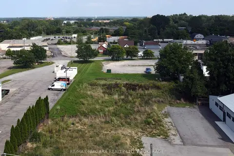
$3/mo
4354 DRUMMOND Road
211 - Cherrywood, Niagara Falls
Land · MLS® X12454464 · RE/MAX NIAGARA REALTY LTD, BROKERAGE