505 Kenora Avenue
Nashdale, Hamilton, L8E 3P2
$27,000,000
Reduced $2,950,000 from $29,950,000
Listed 539 days ago · MLS® X12110169
About this home
Prime 10.1-acre industrial site in Hamilton's Nashdale industrial corridor, just minutes from the QEW and Centennial Parkway interchange. This M5-zoned property features three freestanding buildings totaling 76,706 SF with low site coverage and significant excess land, making it ideal for investors, owner-users, and developers. The property consists of multiple individual parcels, allowing for potential severance and resale to lower the cost basis. Building A offers 27,550 SF with 15'8" clear height, 9 dock doors, and 2 drive-in bays. Building B offers 22,265 SF with 13'2" clear height, 6 drive-in doors, and 2 dock doors. Building C offers 26,891 SF with 25'7" clear height and 8 drive-in doors. With approximately 17% site coverage, there is ample room for expansion, including additional industrial buildings, truck terminals, logistics hubs, or outdoor storage. M5 zoning allows for a wide range of permitted uses, including logistics, warehousing, manufacturing, and truck parking. Nearly all tenants are on month-to-month leases, providing flexibility to offer the site almost entirely vacant or continue generating income. Multiple access points from Kenora Avenue and Nash Road North provide excellent connectivity to major transportation routes. Fully serviced with individual hydro and gas meter, a bulk water meter, gas-fired forced-air heater, and HVAC in office areas. A rare opportunity for an owner-user seeking functional industrial space with room to grow, an investor looking for a high-demand asset, or a developer aiming to maximize site coverage and long-term value.
Details
- Type
- Land
- Lot
- 10.1 × ? ft
- Garage
- Outside/Surface
- Property tax
- $181,936 (2024)
- Neighbourhood
- Nashdale
- Municipality
- Hamilton
Heating, cooling and services
- Water and sewer
- Sanitary+Storm
- Utilities
- Yes
Building and exterior
- Building area
- 10 Acres
More
- Possession
- TBD
- Cross street
- Nash Rd/Kenora Ave
- Business type
- Industrial
History of this address
1 earlier listing at this address, with sold and leased prices. Create a free account or sign in to see them.
Location
Location is approximate. See nearby homes on the map
Recent sales nearby
See what similar homes within 1 km sold for in the last year. Create a free account or sign in to see them.
The neighbourhood
Getting around Walkable
- 🚆 Confederation GO7 min walk
Within a 10-minute walk: 3 grocery stores, 7 cafés and restaurants, 1 park. Nearest grocery: Lococo's (750 m). Nearest park: Confederation Park (800 m).
Schools nearby
Elementary
- Hillcrest Elementary Public School
EQAO: Gr 6 reading 64%, math 16%1.3 km - Lake Avenue Public School
EQAO: Gr 6 reading 64%, math 10%1.6 km - St. Agnes Catholic Elementary School Catholic
EQAO: Gr 6 reading 89%, math 33%2.2 km - St. David Catholic Elementary School Catholic
EQAO: Gr 6 reading 93%, math 45%2.3 km
Secondary
- St. Charles Adult & Continuing Education Centre - Stoney Creek Campus Catholic1.4 km
- Glen Brae Middle School2.4 km
- Glendale Secondary School
EQAO: Gr 9 math 38%, literacy test 78%2.5 km
EQAO: share of students meeting the provincial standard (2024–25). Ontario average: Gr 6 reading 86%, math 51%; Gr 9 math 55%; literacy test 83%.
Closest schools, not school zones. Check which school serves this address with the school board before relying on it.
Who lives here postal area L8E
- Owners / renters
- 71% / 29%
- Median household income
- $91,000
- Average age
- 41
- Children under 15
- 17%
- Homes
- 53% detached, 23% high-rise
- Commute by transit
- 4%
- Population
- 41,927
Languages spoken most at home besides English: Punjabi (Panjabi) 3.6%, Urdu 1.7%, Arabic 1.6%, Italian 1.4%.
Flood and conservation No mapped hazard
Not inside a mapped flood plain or regulated area in Niagara Peninsula Conservation’s mapping.
Screening maps only. Ask the conservation authority for a property inquiry before relying on this.
Safety
Crime Severity Index for Hamilton police: 62 vs 57 for Ontario (2025).
Police-reported figures for the whole police service area, not this street. Rates use the area’s resident population.
Distances are approximate. Places © OpenStreetMap contributors. Neighbourhood figures: Statistics Canada, 2021 Census. School results: EQAO via Ontario Data Catalogue (Open Government Licence – Ontario). Flood and regulation mapping: Niagara Peninsula Conservation open data. Crime Severity Index: Statistics Canada.
Living here
Commute
To downtown Hamilton: 9 km. Transit times · Driving times
Noise 2 sources nearby
- 🛣️ Red Hill Valley Parkway250 m
- 🚆 Rail line (Grimsby Subdivision)300 m
Distances from the map, not noise measurements. Visit at rush hour to judge for yourself.
Internet High-speed
50/10 Mbps or faster available here by cable, fibre or DSL (the federal high-speed target).
From the federal broadband map. Check exact speeds and providers for the address.
Roads, rail, airports and planned stations © OpenStreetMap contributors. Internet: Innovation, Science and Economic Development Canada, National Broadband Data.
Listed by COLLIERS.
Listing information provided by PropTx Innovations Inc. and TRREB; deemed reliable but not guaranteed accurate by PropTx.
Similar homes nearby
See more in Hamilton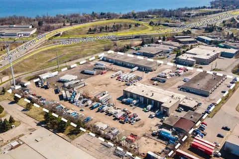
$27,000,000
Reduced $2,950,000
505 Kenora Avenue
Nashdale, Hamilton
Industrial · MLS® X12110176 · COLLIERS