279 ST ANDREW Street
4002 - Lower Town, Lower Town - Sandy Hill, K1N 5G8
$1,399,900
Listed 109 days ago · MLS® X13517736
About this home
Rare opportunity to acquire a large parcel in one of Ottawa's most strategic downtown locations. This solid six-unit building features five 1-bedroom units and one spacious 3-bedroom unit, with the sale also including the adjacent parking lot, creating a substantial land holding just minutes from Parliament Hill, Foreign Affairs, the ByWard Market, the University of Ottawa, and countless shops, restaurants, and employment hubs. The property can be taken over as a turnkey income-producing investment with all units currently tenanted, providing immediate rental revenue, or reimagined as a future redevelopment site in a highly desirable urban location. Combined with the generous yard and parking area, this offering presents exceptional potential for investors, developers, and land bankers alike. Property is being sold in "as-is, where-is" condition. 6.2% cap rate. All units are tenanted and a minimum of 24 hours' notice is required for all showings.
Details
- Type
- Investment
- Lot
- 59.43 × 99.47 ft
- Garage
- None
- Property tax
- $18,619 (2025)
- Neighbourhood
- 4002 - Lower Town
- Municipality
- Lower Town - Sandy Hill
Heating, cooling and services
- Heating
- Baseboard
- Utilities
- Yes
Building and exterior
- Building area
- 0 Acres
More
- Possession
- TBD
- Cross street
- King Edward & St Andrew
- Business type
- Apts - 6 To 12 Units
History of this address
2 earlier listings at this address, with sold and leased prices. Create a free account or sign in to see them.
Location
Location is approximate. See nearby homes on the map
Recent sales nearby
See what similar homes within 1 km sold for in the last year. Create a free account or sign in to see them.
The neighbourhood
Getting around Very walkable
- 🚇 Rideau LRT14 min walk
- 🚇 uOttawa LRT1.6 km
Within a 10-minute walk: 3 grocery stores, 129 cafés and restaurants, 12 parks, 10 pharmacies. Nearest grocery: Loblaws (600 m). Nearest park: Rose Park (50 m).
Schools nearby
Elementary
- York Street Public School
EQAO: Gr 6 reading 65%, math 20%9 min walk - École Notre-Dame du Mont Carmel French · Private9 min walk
- École élémentaire catholique Sainte-Anne Catholic · French
EQAO: Gr 6 reading 100%, math 81%9 min walk - Fern Hill School Private17 min walk
Secondary
- École secondaire publique De la Salle French5 min walk
- MacDonald-Cartier Academy Private12 min walk
- Lisgar Collegiate Institute
EQAO: Gr 9 math 73%, literacy test 91%1.5 km
EQAO: share of students meeting the provincial standard (2024–25). Ontario average: Gr 6 reading 86%, math 51%; Gr 9 math 55%; literacy test 83%.
Closest schools, not school zones. Check which school serves this address with the school board before relying on it.
Who lives here postal area K1N
- Owners / renters
- 24% / 76%
- Median household income
- $64,000
- Average age
- 40
- Children under 15
- 9%
- Homes
- 4% detached, 49% high-rise
- Commute by transit
- 23%
- Population
- 26,639
Languages spoken most at home besides English: Mandarin 1.5%, Arabic 1.3%, Spanish 0.9%, Somali 0.6%.
Distances are approximate. Places © OpenStreetMap contributors. Neighbourhood figures: Statistics Canada, 2021 Census. School results: EQAO via Ontario Data Catalogue (Open Government Licence – Ontario).
Living here
Commute
To downtown Ottawa: 2 km. Transit times · Driving times
Noise 1 source nearby
- 🛣️ Highway400 m
Distances from the map, not noise measurements. Visit at rush hour to judge for yourself.
Internet High-speed
50/10 Mbps or faster available here by cable, fibre or DSL (the federal high-speed target).
From the federal broadband map. Check exact speeds and providers for the address.
Roads, rail, airports and planned stations © OpenStreetMap contributors. Internet: Innovation, Science and Economic Development Canada, National Broadband Data.
Listed by CENTURY 21 SYNERGY REALTY INC.
Listing information provided by PropTx Innovations Inc. and TRREB; deemed reliable but not guaranteed accurate by PropTx.
Similar homes nearby
See more in Lower Town - Sandy Hill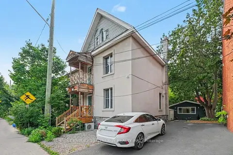
$1,325,000
95 Templeton Street
4004 - Sandy Hill, Lower Town - Sandy Hill
Investment · MLS® X13539778 · CENTURY 21 SYNERGY REALTY INC