1016 Talbot Street
St. Thomas, St. Thomas, N5P 1G3
$1/mo
Listed 138 days ago · MLS® X13238426
About this home
1016 Talbot Street is a high-visibility commercial property located on St. Thomas's primary retail corridor, currently being repositioned and extensively renovated into a modern multi-tenant plaza.The building is a single-storey free-span structure situated on a 16,554 sq ft lot, offering approximately 10,000 sq ft of dividable leasable space. The property is undergoing a full transformation featuring new corrugated metal siding with angled accent panels, a stone veneer base, aluminum-frame storefronts, and new washrooms, HVAC, and electrical systems in each unit. Optional patio space is available, and a prominent pylon sign on Talbot Street - combined with up to 54 on-site parking spots - ensures strong tenant visibility and convenient customer access. Zoned C7-33 under City of St. Thomas By-law 50-88 (as amended by By-law 60-2024), the property accommodates an exceptionally broad range of permitted uses, including professional offices, pharmacy/drugstore, medical and health clinics, automotive parts and services, building supplies, restaurants and cafés, specialty retail, craft breweries, and entertainment centres. This flexibility makes it well-suited for a diverse mix of service, food, health, and professional tenants. Zoning: C7-33 Lot Size: 16,554 sq ft. Leasable Area: ~10,000 sq ft (divisible units available). *For Additional Property Details Click The Brochure Icon Below*
Details
- Type
- Commercial Retail
- Lot
- 134.8 × 124.7 ft
- Garage
- None
- Kitchens
- 0
- Property tax
- $11,742 (2025)
- Neighbourhood
- St. Thomas
- Municipality
- St. Thomas
Heating, cooling and services
- Heating
- Gas Forced Air Open, Gas
- Air conditioning
- Yes
- Utilities
- Available
Building and exterior
- Building area
- 9,708 Square Feet
Rental terms
- Minimum term
- 60 months
More
- Possession
- Sept October
- Cross street
- First Street
Location
Location is approximate. See nearby homes on the map
The neighbourhood
Getting around Walkable
No subway, LRT or GO station within a short trip.
Within a 10-minute walk: 3 grocery stores, 11 cafés and restaurants, 1 park, 2 pharmacies. Nearest grocery: Briwood Farm Market (350 m). Nearest park: Canron Parkette (300 m).
Schools nearby
Elementary
- Forest Park Public School
EQAO: Gr 6 reading 64%, math 39%11 min walk - June Rose Callwood Public School
EQAO: Gr 6 reading 74%, math 18%18 min walk - St. Anne's Separate School Catholic
EQAO: Gr 6 reading 85%, math 39%1.2 km - Pierre Elliott Trudeau French Immersion Public School
EQAO: Gr 6 reading 100%, math 66%1.3 km
Secondary
- Balaclava Street Adult Learning Centre15 min walk
- Central Elgin Collegiate Institute
EQAO: Gr 9 math 50%, literacy test 79%16 min walk - Arthur Voaden Secondary School
EQAO: Gr 9 math 27%, literacy test 48%1.3 km
EQAO: share of students meeting the provincial standard (2024–25). Ontario average: Gr 6 reading 86%, math 51%; Gr 9 math 55%; literacy test 83%.
Closest schools, not school zones. Check which school serves this address with the school board before relying on it.
Who lives here postal area N5P
- Owners / renters
- 68% / 32%
- Median household income
- $77,500
- Average age
- 42
- Children under 15
- 17%
- Homes
- 69% detached, 6% high-rise
- Commute by transit
- 0%
- Population
- 21,081
Languages spoken most at home besides English: Polish 0.2%, Vietnamese 0.2%, Spanish 0.2%, Gujarati 0.1%.
Safety
Crime Severity Index for St. Thomas police: 62 vs 57 for Ontario (2025).
Police-reported figures for the whole police service area, not this street. Rates use the area’s resident population.
Distances are approximate. Places © OpenStreetMap contributors. Neighbourhood figures: Statistics Canada, 2021 Census. School results: EQAO via Ontario Data Catalogue (Open Government Licence – Ontario). Crime Severity Index: Statistics Canada.
Living here
Commute
To downtown London: 24 km. Transit times · Driving times
Noise 1 source nearby
- 🚆 Rail line (St. Thomas Subdivision)250 m
Distances from the map, not noise measurements. Visit at rush hour to judge for yourself.
Internet High-speed
50/10 Mbps or faster available here by cable, fibre or DSL (the federal high-speed target).
From the federal broadband map. Check exact speeds and providers for the address.
Roads, rail, airports and planned stations © OpenStreetMap contributors. Internet: Innovation, Science and Economic Development Canada, National Broadband Data.
Listed by ICI SOURCE REAL ASSET SERVICES INC..
Listing information provided by PropTx Innovations Inc. and TRREB; deemed reliable but not guaranteed accurate by PropTx.
Similar homes nearby
See more in St. Thomas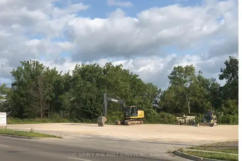
$1/mo
1020 Talbot Street
St. Thomas, St. Thomas
Land · MLS® X13410710 · ICI SOURCE REAL ASSET SERVICES INC.