The Carlyle

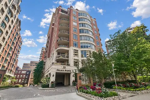
55 Delisle Ave, Toronto. 2 condos for sale in this building right now. In Yonge-St. Clair.

For sale
2
For rent
0
Asking price per sq ft
$902
Maintenance fee per sq ft
$1.31
Storeys
9

About the building

Address
55 Delisle Ave, Toronto
Building name
The Carlyle
Age
16-30 years
Pets
Yes-with Restrictions
Property manager
Crossbridge
Units seen listed
36

Amenities

  • BBQs Allowed
  • Concierge
  • Exercise Room
  • Guest Suites
  • Party Room/Meeting Room
  • Visitor Parking

From the listings in this building; details can vary by unit and change over time.

For sale in this building

Recent sales and rentals

51 past sales and rentals in this building, with prices. Create a free account or sign in to see them.

The neighbourhood

Getting around Very walkable

  • 🚇 St. Clair Subway5 min walk
  • 🚇 Summerhill Subway14 min walk
  • 🚆 Toronto Union Station GO5.0 km

Within a 10-minute walk: 3 grocery stores, 42 cafés and restaurants, 7 parks, 6 pharmacies. Nearest grocery: Loblaws (250 m). Nearest park: Amsterdam Square (350 m).

Schools nearby

Elementary

  • The York School - Junior Campus Private7 min walk
  • Deer Park Junior and Senior Public School
    EQAO: Gr 6 reading 89%, math 68%
    8 min walk
  • Brown Junior Public School
    EQAO: Gr 6 reading 100%, math 75%
    8 min walk
  • Upper Canada College Private12 min walk

Secondary

  • De La Salle College "Oaklands" Private10 min walk

EQAO: share of students meeting the provincial standard (2024–25). Ontario average: Gr 6 reading 86%, math 51%; Gr 9 math 55%; literacy test 83%.

Closest schools, not school zones. Check which school serves this address with the school board before relying on it.

Who lives here postal area M4V

Owners / renters
44% / 56%
Median household income
$99,000
Average age
46
Children under 15
10%
Homes
11% detached, 63% high-rise
Commute by transit
26%
Population
19,273

Languages spoken most at home besides English: Spanish 1.3%, Mandarin 0.8%, Russian 0.7%, Iranian Persian 0.6%.

Flood and conservation No mapped hazard

Not inside a mapped flood plain or regulated area.

Screening maps only. Ask the conservation authority for a property inquiry before relying on this.

Safety

Major crime per resident in Yonge-St.Clair (2025): 42% below the Toronto average, about the same from the year before.

  • Assault65% below average
  • Break and enter97% above average
  • Auto theft71% below average
  • Robbery67% below average
  • Theft from vehicles45% below average
  • Shootingsnone reported

Crime Severity Index for Toronto police: 60 vs 57 for Ontario (2025).

Police-reported figures for the whole neighbourhood, not this street. Rates use the area’s resident population.

Development nearby 27 active

  • 1560 YONGE ST · 200 m
    Site Plan · Application Received · applied 2026
    Proposed four storey community centre with a gross floor area of 6,166sqm.
    Application details
  • 1497 YONGE ST · 250 m
    Site Plan · Under Review · applied 2026
    Mixed use development consisting of three towers organized around a central publicly accessible open space (POPS), along with a new 1,560 m² public park at the…
    Application details
  • 135 ST CLAIR AVE W · 400 m
    Site Plan · Under Review · applied 2025
    Proposed 49 storey mixed-use, 544-unit residential tower containing 46,009sqm residential GFA and 920sqm non-residential GFA, with a total height of 164.3…
    Application details
  • 15 DELISLE AVE · 150 m
    Plan of Condominium · Draft Plan Approved · applied 2025
    Draft Plan of Condominium for 371 dwelling units.
    Application details
  • 59 LAWTON BLVD · 450 m
    Site Plan · Under Review · applied 2025
    Site Plan Approval for two new 38 and 43-storey residential buildings. The proposed development will be comprised of 706 residential units.
    Application details
  • 59 LAWTON BLVD · 450 m
    Official Plan / Zoning By-law Amendment · OMB Appeal · applied 2025
    OLT Interim Order for Approval of two new 37 and 38-storey residential buildings subject to fulfillment of conditions.
    Application details

26 more within 500 m.

Rezoning, site plan, subdivision and condominium applications filed with the city.

Distances are approximate. Places © OpenStreetMap contributors. Neighbourhood figures: Statistics Canada, 2021 Census. School results: EQAO via Ontario Data Catalogue (Open Government Licence – Ontario). Neighbourhood crime: Toronto Police Service Public Safety Data Portal (Open Government Licence – Toronto Police Service). Crime Severity Index: Statistics Canada. Planning applications: City of Toronto open data.

Get an email when a unit here is listed

Be first to know about new listings in The Carlyle.

Thinking of selling a unit here? See what it’s worth or talk to Mehran.