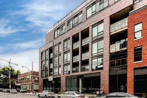
246 Logan Ave

1 condo for rent in this building right now. In South Riverdale.

For sale
0
For rent
1
Storeys
2

About the building

Address
246 Logan Ave, Toronto
Pets
Yes-with Restrictions
Property manager
Icon Property Management
Units seen listed
101

From the listings in this building; details can vary by unit and change over time.

For rent in this building

Recent sales and rentals

194 past sales and rentals in this building, with prices. Create a free account or sign in to see them.

The neighbourhood

Getting around Very walkable

  • 🚇 Chester Subway2.2 km
  • 🚇 Pape Subway2.2 km
  • 🚆 Toronto Union Station GO3.5 km

Within a 10-minute walk: 11 grocery stores, 88 cafés and restaurants, 21 parks, 8 pharmacies. Nearest grocery: Leslieville Cheese Market East & Fine Foods (50 m). Nearest park: John Chang Neighbourhood Park (250 m).

Schools nearby

Elementary

  • Morse Street Junior Public School
    EQAO: Gr 6 reading 85%, math 71%
    3 min walk
  • Dundas Junior Public School
    EQAO: Gr 3 reading 66%, math 53%
    8 min walk
  • Bruce Public School
    EQAO: Gr 6 reading 93%, math 43%
    12 min walk
  • St. Joseph Catholic School Catholic
    EQAO: Gr 6 reading 92%, math 58%
    16 min walk

Secondary

  • Queen Alexandra Middle School10 min walk
  • SEED Alternative School10 min walk
  • Eastdale Collegiate Institute13 min walk

EQAO: share of students meeting the provincial standard (2024–25). Ontario average: Gr 6 reading 86%, math 51%; Gr 9 math 55%; literacy test 83%.

Closest schools, not school zones. Check which school serves this address with the school board before relying on it.

Who lives here postal area M4M

Owners / renters
56% / 44%
Median household income
$99,000
Average age
40
Children under 15
14%
Homes
6% detached, 25% high-rise
Commute by transit
25%
Population
25,052

Languages spoken most at home besides English: Yue (Cantonese) 6.3%, Mandarin 3.5%, Vietnamese 1.5%, Spanish 0.6%.

Flood and conservation No mapped hazard

Not inside a mapped flood plain or regulated area.

Screening maps only. Ask the conservation authority for a property inquiry before relying on this.

Safety

Major crime per resident in South Riverdale (2025): about the Toronto average, down 17% from the year before.

  • Assaultabout average
  • Break and enter40% above average
  • Auto theftabout average
  • Robberyabout average
  • Theft from vehicles65% above average
  • Shootings61% below average

Crime Severity Index for Toronto police: 60 vs 57 for Ontario (2025).

Police-reported figures for the whole neighbourhood, not this street. Rates use the area’s resident population.

Development nearby 12 active

  • 65-87 HEWARD AVE · 500 m
    Official Plan / Zoning By-law Amendment · OMB Appeal · applied 2025
    Official Plan Amendment (OPA) to re-designate the subject site from Core Employment Areas to Mixed Use Areas to permit future mixed-use development. The OPA…
    Application details
  • 797 QUEEN ST E · 350 m
    Site Plan · Under Review · applied 2024
    Site Plan Control Placeholder for Leslieville Station, one of the stations included in the Ontario Line Elevated Guideway and Stations contract.
    Application details
  • 462 EASTERN AVE · 250 m
    Plan of Condominium · Draft Plan Approved · applied 2024
    Draft Plan of Condominium for 1 storey retail condominium, consisting of 5 retail condominium units and 10 parking units.
    Application details
  • 929 QUEEN ST E · 150 m
    Site Plan · NOAC Issued · applied 2023
    Application for Site Plan Control to permit a 9-storey mixed use building, containing 78 rental units and 195 square metres of commercial gross floor area.
    Application details
  • 786 QUEEN ST E · 400 m
    Site Plan · NOAC Issued · applied 2023
    Site Plan application to permit a 6 storey mixed use building, containing 15 residential units and 69.64 square metres of ground floor commercial GFA.
    Application details
  • 26 B LEWIS ST · 450 m
    Plan of Subdivision · Under Review · applied 2021
    Draft Plan of Subdivision for 2 blocks.
    Application details

9 more within 500 m.

Rezoning, site plan, subdivision and condominium applications filed with the city.

Distances are approximate. Places © OpenStreetMap contributors. Neighbourhood figures: Statistics Canada, 2021 Census. School results: EQAO via Ontario Data Catalogue (Open Government Licence – Ontario). Neighbourhood crime: Toronto Police Service Public Safety Data Portal (Open Government Licence – Toronto Police Service). Crime Severity Index: Statistics Canada. Planning applications: City of Toronto open data.

Get an email when a unit here is listed

Be first to know about new listings in 246 Logan Ave.

Thinking of selling a unit here? See what it’s worth or talk to Mehran.