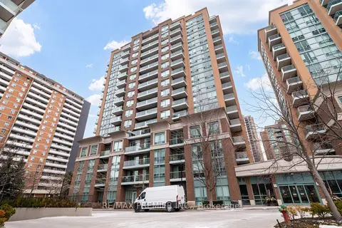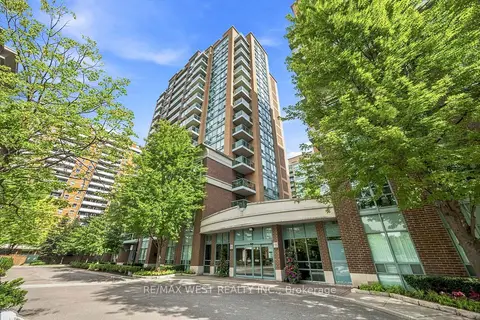
15 Michael Power Pl

2 condos for sale in this building right now. In Islington-City Centre West.

For sale
2
For rent
0
Asking price per sq ft
$736
Maintenance fee per sq ft
$1.17
Storeys
16

About the building

Address
15 Michael Power Pl, Toronto
Age
16-30 years
Pets
Yes-with Restrictions
Property manager
Del Property Management
Units seen listed
85

Amenities

  • Elevator
  • Exercise Room
  • Game Room
  • Party Room/Meeting Room
  • Playground
  • Recreation Room

From the listings in this building; details can vary by unit and change over time.

For sale in this building

Recent sales and rentals

162 past sales and rentals in this building, with prices. Create a free account or sign in to see them.

The neighbourhood

Getting around Very walkable

  • 🚇 Islington Subway7 min walk
  • 🚇 Kipling Subway15 min walk
  • 🚆 Kipling GO1.2 km

Within a 10-minute walk: 7 grocery stores, 37 cafés and restaurants, 4 parks, 8 pharmacies. Nearest grocery: Apna Food Bazaar (500 m). Nearest park: Michael Power Park (100 m).

Schools nearby

Elementary

  • Islington Junior Middle School
    EQAO: Gr 6 reading 84%, math 41%
    4 min walk
  • Filipok Russian Junior School8 min walk
  • Our Lady of Peace Catholic School Catholic
    EQAO: Gr 6 reading 84%, math 60%
    14 min walk
  • Our Lady of Sorrows Catholic School Catholic
    EQAO: Gr 6 reading 95%, math 75%
    15 min walk

Secondary

  • Etobicoke Collegiate Institute
    EQAO: Gr 9 math 73%, literacy test 90%
    13 min walk

EQAO: share of students meeting the provincial standard (2024–25). Ontario average: Gr 6 reading 86%, math 51%; Gr 9 math 55%; literacy test 83%.

Closest schools, not school zones. Check which school serves this address with the school board before relying on it.

Who lives here postal area M9A

Owners / renters
51% / 49%
Median household income
$93,000
Average age
44
Children under 15
13%
Homes
32% detached, 58% high-rise
Commute by transit
24%
Population
36,642

Languages spoken most at home besides English: Spanish 2.3%, Ukrainian 2.1%, Portuguese 1.7%, Korean 1.5%.

Flood and conservation No mapped hazard

Not inside a mapped flood plain or regulated area.

Screening maps only. Ask the conservation authority for a property inquiry before relying on this.

Safety

Major crime per resident in Etobicoke City Centre (2025): 55% above the Toronto average, down 9% from the year before.

  • Assaultabout average
  • Break and enterabout average
  • Auto theft167% above average
  • Robbery139% above average
  • Theft from vehicles32% above average
  • Shootings98% above average

Crime Severity Index for Toronto police: 60 vs 57 for Ontario (2025).

Police-reported figures for the whole neighbourhood, not this street. Rates use the area’s resident population.

Development nearby 13 active

  • 1276 ISLINGTON AVE · 450 m
    Site Plan · Under Review · applied 2026
    Proposed infill development of a 35-storey, 25,700.63 square-metre, purpose-built rental building containing 375 residential units, and 262 parking spaces…
    Application details
  • 56 FIELDWAY RD · 450 m
    Site Plan · Under Review · applied 2023
    Site Plan application proposing to redevelop the site into a mixed-use community comprised of four tall buildings at 12, 23, 34 and 42 storeys. The proposal…
    Application details
  • 25 MABELLE AVE · 300 m
    Site Plan · OMB Appeal · applied 2022
    Proposal to redevelop the site with a 49 storey mixed use building containing 79 square metres of retail gross floor area, 580 residential condominium units…
    Application details
  • 4894 DUNDAS ST W · 500 m
    Site Plan · Under Review · applied 2022
    Site Plan Application reflecting Settlement Proposal to permit a 25-storey residential tower with at-grade retail use for OZ/OPA File No. 22 139836 WET 03 OZ.
    Application details
  • 4894 DUNDAS ST W · 500 m
    Official Plan / Zoning By-law Amendment · OMB Appeal · applied 2022
    Official Plan and Zoning By-law Amendment for a 25-storey mixed-use building that includes 398 dwelling units and 4,817 square metres of institutional space…
    Application details
  • 36 FIELDWAY RD · 350 m
    Site Plan · NOAC Issued · applied 2022
    Current SPA resubmission proposes 8,060.9 square metres of total gross floor area (GFA), a Floor Space Index (FSI) of 3.62 times the area of the lot, a mix of…
    Application details

14 more within 500 m.

Rezoning, site plan, subdivision and condominium applications filed with the city.

Distances are approximate. Places © OpenStreetMap contributors. Neighbourhood figures: Statistics Canada, 2021 Census. School results: EQAO via Ontario Data Catalogue (Open Government Licence – Ontario). Neighbourhood crime: Toronto Police Service Public Safety Data Portal (Open Government Licence – Toronto Police Service). Crime Severity Index: Statistics Canada. Planning applications: City of Toronto open data.

Get an email when a unit here is listed

Be first to know about new listings in 15 Michael Power Pl.

Thinking of selling a unit here? See what it’s worth or talk to Mehran.