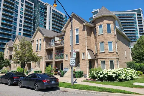
Condo Apartment · MLS® C12687644 · REMAX YOUR COMMUNITY REALTY
The neighbourhood
Getting around Very walkable
🚇 Laird LRT10 min walk
🚇 Sunnybrook Park LRT12 min walk
🚆 Danforth GO5.5 km
Within a 10-minute walk: 4 grocery stores, 14 cafés and restaurants, 4 parks, 2 pharmacies.
Nearest grocery: Farm Boy (450 m).
Nearest park: Radar Park (200 m).
Schools nearby
Elementary
Northlea Elementary and Middle School EQAO: Gr 6 reading 95%, math 82%15 min walk
Bessborough Drive Elementary and Middle School EQAO: Gr 6 reading 93%, math 80%1.3 km
Leaside Children’s House Montessori Private1.3 km
Thorncliffe Park Public School EQAO: Gr 3 reading 37%, math 25%1.4 km
Secondary
Leaside High School EQAO: Gr 9 math 79%, literacy test 95%1.3 km
Valley Park Middle School1.7 km
Marc Garneau Collegiate Institute EQAO: Gr 9 math 34%, literacy test 72%1.9 km
EQAO: share of students meeting the provincial standard (2024–25). Ontario average: Gr 6 reading 86%, math 51%; Gr 9 math 55%; literacy test 83%.
Closest schools, not school zones. Check which school serves this address with the school board before relying on it.
Who lives here postal area M4G
Owners / renters
68% / 32%
Median household income
$130,000
Average age
43
Children under 15
16%
Homes
42% detached, 23% high-rise
Commute by transit
13%
Population
19,598
Languages spoken most at home besides English: Mandarin 0.9%, Spanish 0.8%, Iranian Persian 0.7%, Portuguese 0.7%.
Flood and conservation No mapped hazard
Not inside a mapped flood plain or regulated area.
Screening maps only. Ask the conservation authority for a property inquiry before relying on this.
Safety
Major crime per resident in Thorncliffe Park (2025): about the Toronto average, up 15% from the year before.
Assaultabout average
Break and enter45% below average
Auto theft68% above average
Robberyabout average
Theft from vehiclesabout average
Shootingsnone reported
Crime Severity Index for Toronto police: 60 vs 57 for Ontario (2025).
Police-reported figures for the whole neighbourhood, not this street. Rates use the area’s resident population.
Development nearby 10 active
135 VANDERHOOF AVE· 450 m
Site Plan · Under Review · applied 2026
Site Plan Control Application proposes to develop the site with a 1 storey mezzanine industrial building for two tenants. 4 loading bays and 44 parking spaces…
Official Plan / Zoning By-law Amendment · OMB Appeal · applied 2025
Official Plan Amendment proposes to amend the City of Toronto Official Plan by re-designating the subject site from Core Employment Areas to Mixed Use Areas.…
Proposal for a development includes three buildings: a 40-storey residential mixed-use building, a 21storey residential building, and a 6-storey office…
Part lot control exemption application to establish stratified ownerships of the five mixed-use buildings, as conditionally approved by the OLT in 2020, that…