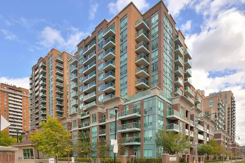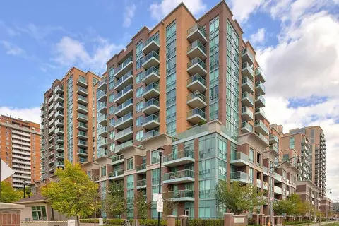
11 Michael Power Pl

1 condo for sale and 1 condo for rent in this building right now. In Islington-City Centre West.

For sale
1
For rent
1
Maintenance fee per sq ft
$0.97
Storeys
7

About the building

Address
11 Michael Power Pl, Toronto
Age
16-30 years
Pets
Yes-with Restrictions
Property manager
N/A
Units seen listed
85

Amenities

  • Exercise Room
  • Game Room
  • Gym
  • Party Room/Meeting Room
  • Visitor Parking

From the listings in this building; details can vary by unit and change over time.

For sale in this building

For rent in this building

Recent sales and rentals

178 past sales and rentals in this building, with prices. Create a free account or sign in to see them.

The neighbourhood

Getting around Very walkable

  • 🚇 Islington Subway7 min walk
  • 🚇 Kipling Subway14 min walk
  • 🚆 Kipling GO18 min walk

Within a 10-minute walk: 7 grocery stores, 38 cafés and restaurants, 4 parks, 8 pharmacies. Nearest grocery: Apna Food Bazaar (550 m). Nearest park: Michael Power Park (100 m).

Schools nearby

Elementary

  • Islington Junior Middle School
    EQAO: Gr 6 reading 84%, math 41%
    5 min walk
  • Filipok Russian Junior School8 min walk
  • Our Lady of Peace Catholic School Catholic
    EQAO: Gr 6 reading 84%, math 60%
    14 min walk
  • Our Lady of Sorrows Catholic School Catholic
    EQAO: Gr 6 reading 95%, math 75%
    15 min walk

Secondary

  • Etobicoke Collegiate Institute
    EQAO: Gr 9 math 73%, literacy test 90%
    13 min walk

EQAO: share of students meeting the provincial standard (2024–25). Ontario average: Gr 6 reading 86%, math 51%; Gr 9 math 55%; literacy test 83%.

Closest schools, not school zones. Check which school serves this address with the school board before relying on it.

Who lives here postal area M9A

Owners / renters
51% / 49%
Median household income
$93,000
Average age
44
Children under 15
13%
Homes
32% detached, 58% high-rise
Commute by transit
24%
Population
36,642

Languages spoken most at home besides English: Spanish 2.3%, Ukrainian 2.1%, Portuguese 1.7%, Korean 1.5%.

Flood and conservation No mapped hazard

Not inside a mapped flood plain or regulated area.

Screening maps only. Ask the conservation authority for a property inquiry before relying on this.

Safety

Major crime per resident in Etobicoke City Centre (2025): 55% above the Toronto average, down 9% from the year before.

  • Assaultabout average
  • Break and enterabout average
  • Auto theft167% above average
  • Robbery139% above average
  • Theft from vehicles32% above average
  • Shootings98% above average

Crime Severity Index for Toronto police: 60 vs 57 for Ontario (2025).

Police-reported figures for the whole neighbourhood, not this street. Rates use the area’s resident population.

Development nearby 11 active

  • 1276 ISLINGTON AVE · 500 m
    Site Plan · Under Review · applied 2026
    Proposed infill development of a 35-storey, 25,700.63 square-metre, purpose-built rental building containing 375 residential units, and 262 parking spaces…
    Application details
  • 56 FIELDWAY RD · 450 m
    Site Plan · Under Review · applied 2023
    Site Plan application proposing to redevelop the site into a mixed-use community comprised of four tall buildings at 12, 23, 34 and 42 storeys. The proposal…
    Application details
  • 25 MABELLE AVE · 300 m
    Site Plan · OMB Appeal · applied 2022
    Proposal to redevelop the site with a 49 storey mixed use building containing 79 square metres of retail gross floor area, 580 residential condominium units…
    Application details
  • 36 FIELDWAY RD · 350 m
    Site Plan · NOAC Issued · applied 2022
    Current SPA resubmission proposes 8,060.9 square metres of total gross floor area (GFA), a Floor Space Index (FSI) of 3.62 times the area of the lot, a mix of…
    Application details
  • 26 BURNHAMTHORPE RD · 450 m
    Site Plan · NOAC Issued · applied 2022
    Proposal for the redevelopment of the subject site with four three-storey apartment buildings, wellness centre building and below grade parking structure. The…
    Application details
  • 3326 BLOOR ST W · 400 m
    Plan of Subdivision · Under Review · applied 2021
    Bloor Kipling Housing Now: Draft Plan of Subdivision to create two mixed-use development blocks and a new public road connecting Green Lanes and Aberfoyle…
    Application details

12 more within 500 m.

Rezoning, site plan, subdivision and condominium applications filed with the city.

Distances are approximate. Places © OpenStreetMap contributors. Neighbourhood figures: Statistics Canada, 2021 Census. School results: EQAO via Ontario Data Catalogue (Open Government Licence – Ontario). Neighbourhood crime: Toronto Police Service Public Safety Data Portal (Open Government Licence – Toronto Police Service). Crime Severity Index: Statistics Canada. Planning applications: City of Toronto open data.

Get an email when a unit here is listed

Be first to know about new listings in 11 Michael Power Pl.

Thinking of selling a unit here? See what it’s worth or talk to Mehran.